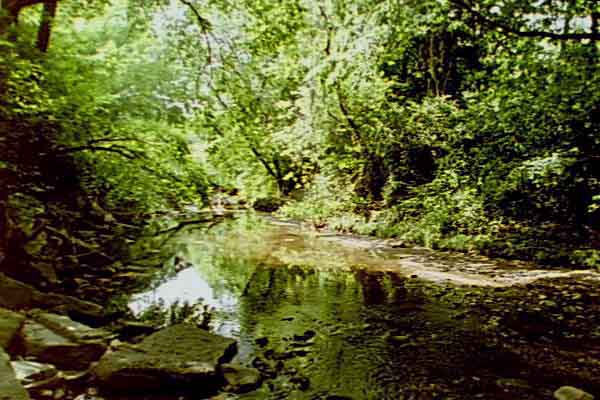
Here is a scene along Pleasant Run, just West of Ritter Avenue.
(See 2 on map.)
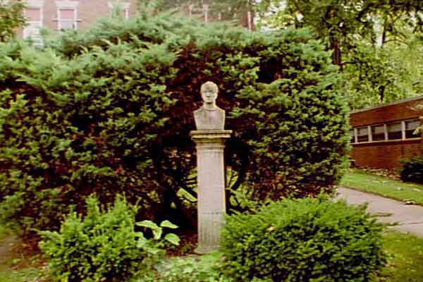
A bust of Washington Irving is located on the grounds of the George
W. Julian elementary school, number 57. This school was established in
1902. There is only one older building in use by the Indianapolis Public
School system. (See 1 on map.)
The boundaries of Irvington are not defined. For the purpose of this
page, Irvington is that part of Indianapolis that is bounded by Emerson
Avenue on the West, Arlington Avenue on the East, Brookville Road on the
South, and Tenth Street on the North. The following map encompasses most
the the area described.

From 1875 until 1928, Butler College was located in the Southwest corner of Irvington.
The Ellenberger farm house was located on the Northwest corner of Ritter Avenue and Pleasant Run Parkway. The house is now gone. (See 3 on map.) Look at this picture to see the site.
The Ellenberger farm is now Ellenberger park. (See 4 on map.) A picture shows part of the park.
The Kingsbury farm was also located in Irvington. The Kingsbury farmhouse is still in use at 348 N. Layman. (Southwest corner of Layman and Michigan, 5 on map.) You can see the house in this picture.
Mrs. Kingsbury came to this house as a bride at age 19. She was still living in this house in her 90's during the early 1950's. One of her sons was named "Layman," (probably named for the street. The street was named for James T. Layman. He was an Irvington resident who had a home on South Audubon Road.) The street is an inviting, shady, brick street, today. Here is how the street looks today.
Here is a picture of the front steps of the Kingsbury house. The author and his family lived in an upstairs apartment in 1951 and 1952.
For many years, the business district of Irvington (approximately from Whittier Place to Audubon Road along Washington Street) was a busy and vibrant place. Although still a business area, many businesses have moved to the malls. Here is a scene looking Northeast along Washington Street from Ritter Avenue.
And here is another scene looking Southwest along Washington Street from Audubon Road.
These pictures were made from the locations marked 6 and 7 on the map.
Although the business district of Irvington is not what it once was, most of the residences have been improved. Many houses have been renovated and their lots are more attractively landscaped than they had been. Here is one such home. Sixty years ago this house was rather plain and the yard was only grass and a few bushes.
Three protestant churches in Irvington are Methodist (8 on map), Presbyterian (9 on map), and Downey Avenue Christian (17 on map.) These are shown, respectively, in the following three pictures.
George W. Julian lived on the Southeast corner of Julian Avenue and Audubon Road. School #57 was named for Mr. Julian. The house is located at 10 on the map) and can be seen in this picture.
Another well-known house is the Stevenson house located on University Avenue and located at 14 on the map) and is shown in this picture. The infamous Stevenson had been the Grand Dragon of the Indiana Ku Klux Klan in 1925 and was sent to prison for the murder of an Irvington woman.
The Benton House had been the residence of Butler's President. It is now the headquarters of the Irvington Historical Society. It may be found at 15 on the map) and is can be seen in this picture.
At one time, Irvington had a Pennsylvania Railroad Depot on South Audubon Road adjacent to the Julian property. The depot was razed many years ago and now there are no railroad tracks. The depot's location is 11 on the map) and you can see a picture of the site.
Just a block South of the depot site is the South Audubon Circle (identified on the map) as 12 and it is shown in this picture. Note the well-kept appearance of this place and a second bust of Washington Irving.
Just a block East of this Circle is the Children's Guardian Home. This institution has been a haven for children at risk for many years. These children are educated in Indianapolis Public Schools in Irvington. It is located at 13 on the map) and can be seen in this picture.
Another famous landmark in Irvington is the Missions Building which had been the headquarters of the Disciples of Christ denomination. The headquarters has now been moved to a downtown location in Indianapolis and plans are underway to turn this building into Senior Citizen Apartments. The author of this web page met his wife while both worked in this building and were married in its chapel over 50 years ago. The location is marked as 17 on the map) See the Missions Building in this picture.
Other interesting locations, which are outside the boundaries of the map, but still identified with Irvington, are: Thomas Carr Howe High School which is not now in operation. It is located on Julian Avenue West of Emerson Avenue. Here is a picture taken from Pleasant Run Parkway.
The original plant of the Lindner Brothers Ice Cream Company was located on the Southeast corner of Catherwood and Washington streets. Lindner Building.
Just East of the Lindner building was a small group of businesses, including a grocery and feed store. Many farm families did their shopping in this area when they came to "town." The remaining stores are shown in this picture.
I hope you have enjoyed visiting Irvington via this web page.
The author enjoyed living in Irvington and attended both school #57 and
Howe High school.